|
|
||||||||||||||||||||||||||||||||||||||||||||||||||||||||||||||||||||||||||||||||||||||||||||||||||||||||||||||||||||||||||||||||||||||||||||||||||||||||||||||||||||||||||||||||||||||||||||||||||||||||||||||||||||||||||||||||||||||||||||||||||||||||||||||||||||||||||||||||||||||||||||||||||||||||
|
|
|
||||||||||||||||||||||||||||||||||||||||||||||||||||||||||||||||||||||||||||||||||||||||||||||||||||||||||||||||||||||||||||||||||||||||||||||||||||||||||||||||||||||||||||||||||||||||||||||||||||||||||||||||||||||||||||||||||||||||||||||||||||||||||||||||||||||||||||||||||||||||||||||||||||||
|
|
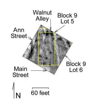
CHAPTER 3F: BLOCK 9
BLOCK 9, LOT 4–HISTORICAL BACKGROUND
The earliest records associated with this lot indicate that Anson Grey had no improvements on the lot in 1867. In 1875 Benjamin Grey was taxed for this lot and he officially acquired the deed in 1884. One year earlier he was taxed for $20 worth of improvements on the lot. The 1870 and 1880 Federal Census lists Grey as a blacksmith. In 1880 he was married to Lizzie, and they had three daughters. In all likelihood, Grey’s blacksmith shop was located on another property. In 1884 Grey sold the lot to George Kimbrew and M. Kimbrew. They held the land until 1909. Oral histories indicate that the “negro schoolhouse” was located on this lot until about 1872. When the Kimbrews acquired the lot and the schoolhouse they partitioned the house, creating a duplex, with each brother living in one section. The deed, tax, and census information follow. The italicized names are those who may have resided on the lot, since they appear in both the deed and census records.
DEED TRANSACTIONS
HADLEY TOWNSHIP RECORDS
1880 FEDERAL CENSUS
BLOCK 9, LOT 4–ARCHAEOLOGY Archaeologists identified a large concentration of artifacts on the western edge of this lot during the 2002/2003 walkover survey. A heavy concentration of nails in the southwest corner also exists, and suggests the presence of structural remains. The 1939 aerial photograph also shows a structure in the southwest corner of the lot. The geophysical survey also identified two amomalies in the southwest corner and the center of the lot. Based on the above information the archaeology team decided to ground truth these two anomalies. This work provides information about the earlist uses of the lot (the school house), the Kimbew occupation, and a possible unknown habitation in the west–central portion of the lot.
Excavation Units 1, 2, and 3 were placed in the southwest corner of Lot 4 with the goal of ground truthing an anomaly (Excavation Unit 2) and finding the remains of the schoolhouse that later served as the Kimbrew residence (Figure 3F.1). The archaeologists excavated in 0.5 ft. arbitrary levels until they encountered natural stratigraphy. At that point they excavated in natural stratigraphy. Generally the plow zone tended to be a 10YR 3/2 (very dark grayish brown) silt and it contained a large quantity of nineteenth– and twentieth– century materials. The subsoil tended to be a 10YR 4/4 (dark yellowish brown) fine grain clay. Generally the subsoil is deeper in the southwestern portion of the lot and archeologists reached it at an average depth of about 0.5 ft. below the surface. In Excavation Unit 4, which is located 60 ft. north of the southwest boundary of the lot, the soil tended to be a 10YR 5/3 (brown) silty clay. The subsoil is about 0.2 ft. to 0.3 ft. below the surface.
Figure 3F.1. Location of excavation units in Block 9, Lot 4 (Drawn by Carrie Christman, Eva Pajuelo and Alison Azzarello). (click image for larger view)
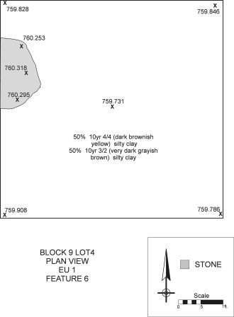
Feature 6 is located in the northwest portion of Excavation Unit 1 (Figure 3F.2 and 3F.3). It is probably a stone pier that supported a building. The base of the pier rests upon the subsoil and it measures 1.5 ft. north–south. It’s western portion is in an unexcavated portion of the site, directly to the west of Excavation Unit 1.
Figure 3F.2. Plan view of Feature 6 in Excavation Unit 1 (Drawn by Carrie Christman). (click image for larger view)
Figure 3F.3. Fieldstone Pier in Block 9, Lot 4 (Photograph by Christopher Valvano).
Excavation Units 5 and 6 were placed in the center of Lot 4 in order to ground truth an identified anomaly. The soil tended to be a 10YR 5/3 (brown) fine grained silt. The subsoil is about 0.2 ft. below the surface. Few artifacts dating to the nineteenth and twentieth century were found in these units. The disking scars are still visible on the top of the subsoil.
It appears that while a large proportion of top soil remains in the southwest portion of this lot, erosion has impacted the rest of the lot. Subsoil is only 0.2 ft. below the surface in the central portion of the lot. The stone pier is likely to be associated with the Kimbrew residence that may have previously served as the “negro schoolhouse.”
BLOCK 9, LOT 5–HISTORICAL BACKGROUND
Frank McWorter sold Block 9, Lot 5 to Kizie (also known as Kessiah and Casiah) Clark in 1854. While Kizie Clark does not show up in the 1855 State Census records, Kizie is most likely Casiah Clark, who is noted in the 1850 federal census. The Hadley township records indicate that Kessiah owned lot 5 until her death in 1888. The lot had $25 in improvements in 1867, although in 1868 the improvements decrease to $3. In 1871 the improvements were again assessed at $25. Casiah’s son, Thomas, listed as 11 years old in the 1850 federal census, sold the lot to William Butler in1888 with a small structure or some other type of improvement on the lot. Both the Clarks and the Butlers appear in the census records and based on oral histories we are certain that the Butlers resided in New Philadelphia on Block 9, Lot 5. The following are the deed, tax and census information. The italicized names are those who may have resided on the lot, since they appear in both the deed and census records.
DEED TRANSACTIONS
HADLEY TOWNSHIP RECORDS
1850 FEDERAL CENSUS
(**Note: Kizie Clark is probably Casiah Clark. She is living with Louisa McWorter in the 1870 and 1880 Federal Census)
1880 FEDERAL CENSUS
BLOCK 9, LOT 5–ARCHAEOLOGY Excavation Units 1, 2, and 3The walkover survey indicates that Block 9, Lot 5, had a very large concentration of artifacts with a mean ceramic date of 1859. The 1939 aerial photograph shows a structure in the southwestern edge of Block 9, Lot 5. By this time the structure served as a storage place; the main domestic dwelling inhabited by the Butlers no longer survived on the landscape. Because of the high density of artifacts, and the probability of finding a domestic structure in the area, a geophysical survey was performed on Block 9, Lots 4 and 5 by Hargrave (2004) in April, 2004 (Figure 3F.4).
Figure 3F.4. Resistivity survey of Block 9, Lot 5. (From Hargrave 2004. Grid overlay by Christopher Fennell.)
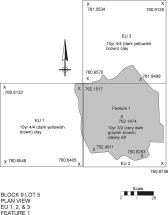
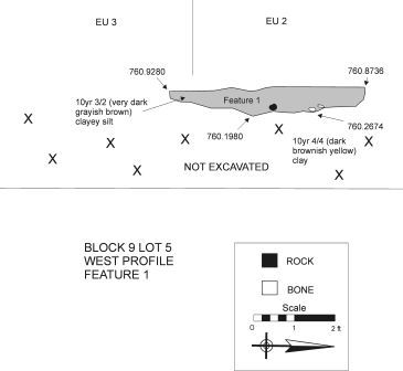
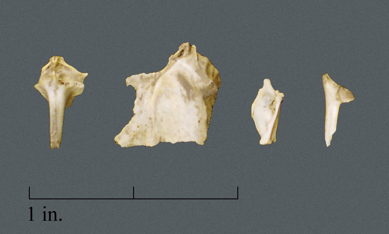
While a strong anomaly could not be detected in the southwest corner of Lot 5, Excavation Units 1, 2 and 3 were placed in the approximate location of the structure identified on the aerial photograph (Figure 3F.5). Generally, the plow zone exists to a depth of about 0.8 ft. to 0.9 ft. below the surface. The soil tends to be a 10YR3/2 (very dark grayish brown) silty loam and clayey silt. Large quantities of brick and mortar as well as household goods are present. Under the plowzone archaeologists noticed a darker colored (10YR3/2 – very dark grayish brown) soil when compared to the surrounding (10YR4/4 – dark yellowish brown) subsoil and designated this area as Feature 1. Most of the feature lies in Excavation Unit 2. The western boundary is in the eastern half of Excavation Unit 1 and the northern portion of the feature is in the southern part of Excavation Unit 3 (Figures 3F.6, 3F.7, and 3F.8). The entire feature measures about 5.0 x 5.0 ft. and it extends to a depth of about 0.5 ft. below the plow zone. It has a concave shape and is probably a cellar. The archaeology team bisected the feature on a north–south axis and excavated the western portion. Soil samples were also retrieved for flotation. The materials from the feature date from the 1850s until about 1870 and are probably associated with Casiah Clark’s occupation of this lot. Casiah acquired the deed to the lot in 1854, but by 1870 Casiah and her family lived with Louisa McWorter in Block 13. The earliest tax records indicate that a small structure sat on this lot valued at $25, and in 1875 the value of improvements is listed as $0. This devaluation may coincide when a structure was dismantled and the cellar filled. Subsequent tax records (1878, 1883, and 1888) show a small structure on the lot. The material objects from the feature include miniature pewter toys, a large quantity of buttons and thimbles, as well as ceramics, glassware, and iron hardware. The faunal assemblage has a large quantity of pig and wild game. Most notable are a few passenger pigeon bones (Figure 3F.9). While passenger pigeon is found in nineteenth–century archaeological assemblages, their presence decreases after the middle of the century and they are extinct in Illinois by about 1900 (Schorger 1973).
Figure 3F.5. Location of units excavated in Block 9, Lot 5 (Drawn by Carrie Christman, Eva Pajuelo and Alison Azzarello). (click on image for larger view)
Figure 3F.6. Plan view of Feature 1 in Excavation Units 1, 2, and 3, in Block 9, Lot 5 (Drawn by Carrie Christman). (click on image for larger view)
Figure 3F.7. Feature 1 bisected (Drawn by Carrie Christman).
Figure 3F.8. West profile of Feature 1 in Block 9, Lot 5 (Drawn by Carrie Christman). (click on image for larger view)
Figure 3F.9. Passenger pigeon bone identified in Feature 1, Block 9, Lot 5 and associated with Cassiah Clark’s occupation of the site (Photograph by Christopher Valvano). (click on image for larger view)
During the excavation of the pit feature a local resident visited the site and remembered walking past the structure daily in order to attend the New Philadelphia schoolhouse in the 1930s (Figure 3F.10). He described the structure in the location of Excavation Units 1–3 as small and very old with a metal roof and an overhang on the north side. He remembered the structure as dilapidated and in poor repair (personal communications, William White). It may have been the building constructed after the 1875 tax assessment.
Figure 3F.10. Identifying the boundaries of Feature 1, Block 9, Lot 5 (Courtesy, Paul A. Shackel).
At present we know that the artifacts from Feature 1 date from the 1850s through the 1860s. While the lot is best known for the Butler occupation, the refuse from the pit feature are associated with the Clark family ownership of the lot. A building, which appears to be relatively smaller than other structures found in New Philadelphia, may date to the mid–nineteenth–century and is probably related to Casiah Clark’s ownership of the lot. She acquired it from Frank McWorter in 1854. The tax records show improvements on the lot from at least 1867 until 1875. Casiah Clark was head of her household in the 1850 Federal Census, and she probably lived on the lot until the late 1860s. The 1870 and 1880 Federal Census shows that she and several of her children lived with Louisa McWorter in Block 13. There is a good chance that her dwelling was dismantled by 1875 since the materials identified in the feature date to about this era. When the structure was dismantled refuse was deposited into the feature and there are no improvements listed on the 1875 tax records.
Since the excavations in Block 9, Lot 5 produced a significant number of artifacts from a pit feature, archaeologists conducted soil core sampling in order to locate additional features and possibly define foundations associated with the structure. Two transects of 19 cores each ran in a north–south direction at 5 ft. intervals (Figure 3F.11). The southernmost portion of transect 1 (T1) is 20 ft. north and 20 ft. east of the southwest corner of Block 9, Lot 5. The southernmost portion of transect 2 (T2) began 20 ft. east of T1, and T2N1 is located 20 ft. north and 40 ft. east of the southwest corner of Block 9, Lot 5.
Figure 3F.11. Coring transects in Block 9, Lot 5 (Drawn by Christopher Fennell). (click on image for larger view)
Generally, each core sample reached a depth of 1.8 ft. below the surface. The uppermost layer consists of a 10YR 3/2 (very dark grayish brown) soil and is located to an average depth of 0.9 ft. below the surface. The soil is the plow zone. The subsoil underlies this layer and generally consists of a 10YR 4/4 (dark yellowish brown) or 10YR 4/3 (brown) mottle 10YR 3/2 (very dark grayish brown).
Resistance to the core probe generally occurred in the northern portion of T1 and through the majority of T2. At T1N14, T1N15, T1N16, and T1N19, and T2N2, T2N3, T2N4, T2N7, T2N10–T2N17 resistance occurred at an average depth of 0.5 ft. below the surface. At T1N1, T1N17, T2N18, T2N9 resistance occurred at a depth that ranged from 1.0 ft. to 1.5 ft. below the surface. Because of this resistance, the archaeology team placed several excavation units along the two transects in order to determine the nature of this coring anomaly (see Excavation Unit Summaries). Originally, the archeology team believed that this resistance may be a stone feature, like a fieldstone foundation. The archaeological investigations revealed that hard–packed clay caused the resistance.
Other Excavation Units – 4,5,6, and 7Because of the coring results and the resistance found in several cores, archaeologists decided to work and decipher the meaning of these anomalies. Excavation Units 4, 5, 6, and 7 were placed in areas where the 1 in. diameter core met resistance. The plow zone varied considerably in this area and subsoil exists anywhere from 0.5 ft. to 1.0 ft. below the surface. The soil tends to be a 10YR3/2 (very dark grayish brown) silty loam, and the subsoil is a 10YR4/4 (dark yellowish brown). The area where the subsoil is closer to the surface may have occurred because of erosion. After excavating these units, archaeologists determined that hard packed clay caused the high resistance during the coring. This area had significantly fewer artifacts than found in the area of Feature 1.
|
|
|
|||||||||||||||||||||||||||||||||||||||||||||||||||||||||||||||||||||||||||||||||||||||||||||||||||||||||||||||||||||||||||||||||||||||||||||||||||||||||||||||||||||||||||||||||||||||||||||||||||||||||||||||||||||||||||||||||||||||||||||||||||||||||||||||||||||||||||||||||||||||||||||||||||||
|
© 2003-2005 University of Maryland
|
|
|||||||||||||||||||||||||||||||||||||||||||||||||||||||||||||||||||||||||||||||||||||||||||||||||||||||||||||||||||||||||||||||||||||||||||||||||||||||||||||||||||||||||||||||||||||||||||||||||||||||||||||||||||||||||||||||||||||||||||||||||||||||||||||||||||||||||||||||||||||||||||||||||||||||